WEATHER 2030:
Transforming the Future
of Forecasting
In 2019, it took Hurricane Michael less than 24 hours to escalate from a category 1 storm into a category 4 – catching forecasters and those in its path dangerously off-guard. Ultimately, Michael slammed into Florida’s panhandle as a devastating category 5. As climate change looms, scientists expect more frequent and intense climate events like these in the future.
Weather satellites play a major role in our lives, from preparing to evacuate immediately or expecting rain a week from now. Advancing satellite capabilities enables forecasters to make more accurate predictions– empowering us to make better decisions, mitigate property damage and most importantly, save lives.
Empowering Critical Decisions
Severe, life-threating weather requires persistent, highly calibrated measurements from thousands of miles above the Earth. With next-generation GEO satellites, organizations like NOAA can leverage mature, modular, flight-proven designs to provide world-leading, exceptional data quality with even greater coverage of weather systems and increase warning times for severe weather.
Ensuring Climate Resiliency
In preparation for a future that could bring stronger hurricanes, more frequent flooding, bigger blizzards, longer heat waves and extended droughts, L3Harris is rapidly evolving its flight-proven weather satellite technology to help NOAA build a robust and resilient satellite constellation capable of more accurate and timely forecasting.
Monitoring Evolving Conditions
From seeing details of hurricanes never seen before, to identifying the faintest of fire hotspots and detecting thunderstorms before clouds even form, L3Harris weather instruments have given us a glimpse into the future of forecasting, both locally and globally. L3Harris is developing a new generation of satellite capabilities that’s even faster and more precise to enhance NOAA’s ability to monitor climate events as they unfold and warn those in harm’s way.
End-to-end solutions for future weather missions
A multi-layered approach to weather observation requires satellites, of various sizes and in multiple orbits, and ground systems working together to ensure critical decision-making data gets in the hands of those who need it most. L3Harris rapidly delivers affordable end-to-end solutions by streamlining sensor development, spacecraft procurement, system integration, launch, ground system and mission operations for our mission partners.
Disclaimer: The future forecasting scenarios presented are theoretical. These scenarios are based on proven mission success and the current trajectory of continued investment in imager, sounder and ground systems technology.
STORMS
SNOW / ICE
Video credit: NOAA
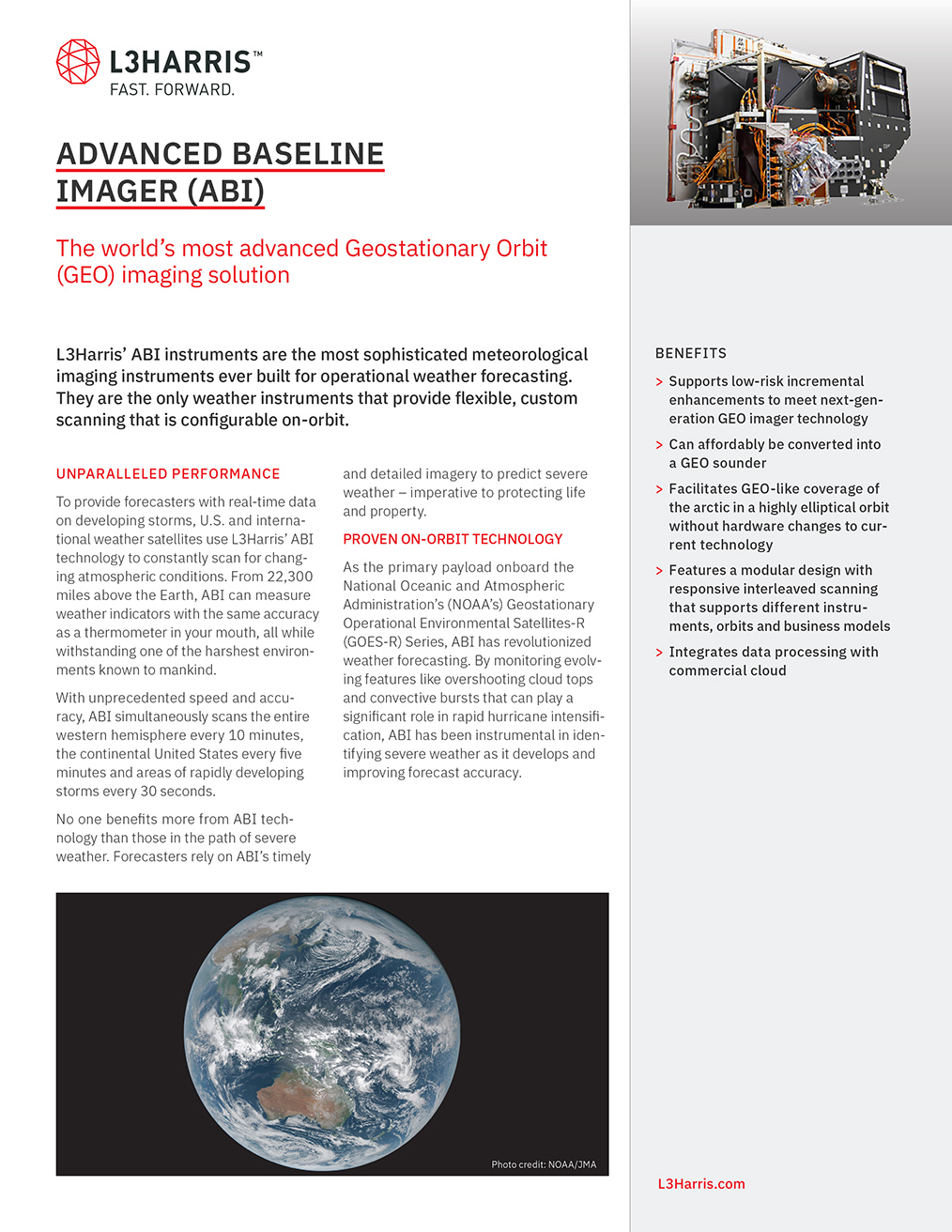
ABI’s flexible design enables L3Harris to evolve its powerful imaging technology with higher spatial and temporal resolution, addi-tional channels for improved data, increased speed with improved data compression to meet future demands.
Advanced Baseline Imager (ABI)
*SHOW DISCLAIMER
Sounding the Alarm
BRINGING BIG DATA DOWN TO EARTH — AT LIGHTNING SPEED
Managing a growing constellation of satellites and sensors, rapidly processing even larger volumes of data and quickly delivering information and products to users worldwide requires a pivot to cloud-native technologies. L3Harris is investing in high-performance computing, machine learning and artificial intelligence technologies to architect a scalable ground system of the future – empowering customers to focus on future missions rather than hardware and facilities.
+5d
+4d
+3d
+2d
+1d
HIGH RISK IN 6 HOURS
SNOW / ICE
FIRE
STORMS
Full Mission Solutions from Space to Ground
2010 Cone
2020 Cone
2030 Cone*
*theoretical
For over 50 years, L3Harris’ breakthrough technology has supported National Oceanic and Atmospheric Administration’s (NOAA’s) mission to protect lives, property and the economy. Now, it’s helping NOAA create a more weather resilient nation by advancing weather satellites for the year 2030 and beyond.
Flexible Rapid Scanning
Fusing its expertise in sounding from LEO and rapid scanning from GEO, L3Harris is developing an innovative geostationary sounder that scans every five minutes instead of every 12 hours from low Earth orbit.
Whether to expect partly cloudy skies, or convection triggered funnel clouds an hour from now relies on high resolution, rapidly refreshed forecasting models.
To feed these data-hungry forecasting models, L3Harris is developing advanced sounders for GEO an LEO that will rapidly increase warning times, enhance long range predictions and better estimate storm intensity.
Refining Forecasting Models
Improved numerical weather predictions
Geostationary Orbit (GEO) Satellites
Provides constant coverage of the same area on Earth’s Western Hemisphere, enabling forecasters to monitor severe weather as it unfolds.
Supplies greater coverage of weather hotspots and increase warning times for thunderstorms, fires, tornadoes, flash floods and other severe weather.
Provides improved data latency through expansion of commercial communication capabilities.
Delivers global data with more frequent refresh to reduce errors in storm track and intensity forecasts, boost forecast confidence and improve storm preparation.
Low Earth Orbit (LEO) Satellites
Drawing on its experience designing and building NOAA’s GOES-R Ground System, L3Harris has proven reliable ground systems and mission operations centers.
Ground systems must efficiently scale to meet future demands.
Ground Systems
L3Harris’ expertise in matching sensor requirements with the right spacecraft ensures customers can take advantage of commercial pricing and are set up for mission success.
Streamlining system integration, spacecraft procurement and commercial launch services enables the entire weather mission.
Spacecraft and Launch
L3Harris rapidly delivers end-to-end mission solutions to our mission partners that reduce costs, on-ramps technology advances and adapts to new business models by streamlining sensor development, spacecraft procurement, system integration, launch, ground system and mission operations.
End-to-End Mission Solutions
NASA has entrusted L3Harris to further develop
its next-generation Geo Visible/Infrared Imager and Geo Hyperspectral Infrared Sounder to advance severe storm tracking, weather fore-casting, climate and other Earth observations.
GEO XO
As the primary payload onboard NOAA’s Geostationary Operational Environmental Satellite-R (GOES-R) Series, ABI has revolutionized weather forecasting.
Building upon the success of GOES-R and ABI, NOAA’s proposed GeoXO constellation seeks to improve its ability to provide timely and accurate weather, ocean, and climate data.
HyperCubes can be flown in a constellation and track changes in the 3D moisture field from one sounding to the next.
L3Harris’ HyperCube™ sounding technology gives access to low-cost global coverage of temperature and moisture data at more than 30 layers of the atmosphere.
HyperCube™
L3Harris is evolving CrIS’s proven, on orbit accuracy with solutions that are smaller and more affordable without sacrificing performance.
Built by L3Harris, NOAA’s Cross-track Infrared Sounder (CrIS) is the most advanced smallsat compatible sounding instrument in LEO and one of the top contributors to forecast accuracy.
CrIS
Designed to accommodate NOAA’s future weather satellite constellation, including a variety of orbits and missions, and to scale data processing capacity on demand
A Cloud-Enabled Future
Maintains high-throughput and low-latency
data processing with high operational availability
Reduces physical footprint, handles higher data rates, and improves real-time processing to feed more frequent weather model runs
Scalable
Reliable
Efficient
From sensors to ground, L3Harris’ capabilities enable the critical decisions that saves lives and property.
Built upon a legacy of mission proven technology, L3Harris’ agility to launch innovative solutions is critical to improving the accuracy of weather forecasts, measuring climate change and increasing life-saving warning times. These advances will ensure NOAA’s mission success for decades to come and create a more weather resilient nation.
Evolving trusted Technology
Scan to Download
VIEW PDF
VIEW PDF
GEOSTATIONARY OPERATIONAL
ENVIRONMENTAL SATELLITE-R
(GOES-R) SERIES
Scan to Download
VIEW PDF
VIEW PDF
CROSS-TRACK INFRARED
SOUNDER (CrIS)
Scan to Download
VIEW PDF
VIEW PDF
Advanced Baseline Imager (ABI)
Scan to Download
VIEW PDF
VIEW PDF
HYPERCUBE™ INFRARED SOUNDING AND 3D WIND MEASUREMENT
Scan to Download
VIEW PDF
VIEW PDF
END-TO-END SMALL SATELLITE SOLUTIONS
Scan to Download
VIEW PDF
VIEW PDF
Small satellite imaging solutions
Whether to expect partly cloudy skies, or convection triggered funnel clouds an hour from now relies on high resolution, rapidly refreshed forecasting models.
To feed these data-hungry forecasting models, L3Harris is developing advanced sounders for GEO an LEO that will rapidly increase warning times, enhance long range predictions and better estimate storm intensity.
Next-gen LEO and GEO sounding technology will produce even more detailed measurements to enable three-dimensional wind speed and direction products, identified by scientists as key to increasing warning times
For over 10 years, the L3Harris built LEO IR Hyperspectral Sounder has been improving the accuracy of forecasts by collecting temperature and moisture profile data for National Weather Service prediction models
Next-gen LEO and GEO sounding technology will produce even more detailed measurements to enable three-dimensional wind speed and direction products, identified by scientists as key to increasing warning times
L3Harris' smallsat mission capabilities provide affordable solutions to expand orbital diversity and improve delivery of actionable intelligence, critical to a more resilient world
Advancing ABI’s capabilities can be affordably achieved with low-risk, high-reward improve-ments to its flight-proven technology
FIRE
FIRE
Video credit: CIRA
Advancing ABI will give scientists a better understanding of the impact snow and ice has on water supply, agriculture, marine navigation, hydropower, flooding, droughts, sea level rise and other growing global concerns.
ABI’s ability to measure snow and ice—one of the most under-sampled parts of the climate system—will be increasingly essential to weather forecasters, climate scientists and numerous industries.
A Rising Concern
Video credit: CIRA
ABI can detect the pooling of low-level moisture (left) that precedes thunderstorm development – approximately one to two hours before any clouds even form (right).
The Calm Before The Storm
Images courtesy of CIRA
Further enhancements to ABI can maximize this unique capability for even earlier storm detection.
Video credit: CIRA
As wildfire activity continues to increase, continued investments in ABI will ensure fire managers and first-responders can act faster and more efficiently.
Before flames or smoke are even observed from the ground, ABI has helped forecasters pinpoint emerging fires – even before the first 911 calls.
Where There’s Smoke, There’s Fire
CURRENT
FUTURE
CURRENT
FUTURE
CURRENT
Data processing capacity of more than
Weather products delivered in less than
Space weather products delivered in
Less than
terabytes
per day
seconds
seconds
seconds
downtime
per year
Mission-Proven GOES-R
Ground System
Fusing its expertise in sounding from LEO and rapid scanning from GEO, L3Harris is developing an innovative geostationary sounder that scans every five minutes instead of every 12 hours from low Earth orbit.
GEO Sounder


As wildfire activity continues to increase, continued investments in ABI will ensure fire managers and first-responders can act faster and more efficiently.
Before flames or smoke are even observed from the ground, ABI has helped forecasters pinpoint emerging fires – even before the first 911 calls.
Where There’s Smoke, There’s Fire


CLOSE


CLOSE


As wildfire activity continues to increase, continued investments in ABI will ensure fire managers and first-responders can act faster and more efficiently.
Before flames or smoke are even observed from the ground, ABI has helped forecasters pinpoint emerging fires – even before the first 911 calls.
Where There’s Smoke, There’s Fire

CLOSE


CLOSE


CLOSE


CLOSE


CLOSE


Whether to expect partly cloudy skies, or convection triggered funnel clouds an hour from now relies on high resolution, rapidly refreshed forecasting models.
To feed these data-hungry forecasting models, L3Harris is developing advanced sounders for GEO an LEO that will rapidly increase warning times, enhance long range predictions and better estimate storm intensity.


Next-gen LEO and GEO sounding technology will produce even more detailed measurements to enable three-dimensional wind speed and direct-ion products, identified by scientists as key to increasing warning times


As wildfire activity continues to increase, continued investments in ABI will ensure fire managers and first-responders can act faster and more efficiently.
Before flames or smoke are even observed from the ground, ABI has helped forecasters pinpoint emerging fires – even before the first 911 calls.
Where There’s Smoke, There’s Fire


DOWNLOAD PDF
DOWNLOAD PDF
DOWNLOAD PDF
DOWNLOAD PDF
DOWNLOAD PDF
DOWNLOAD PDF

Privacy Policy
| Terms of Use


