Boston

INNOVATION
TRACTION
BREEDS


Well-Spaced, Grippy Traction Pads
02

Facet™ 75 Mid OutDry™ features an Adapt Trax™ outsole system that’s designed to provide flexibility where it’s needed by allowing its parts to function independently—say, if you’re on an incline, the outsole can twist while the heel stays at a different angle—helping you grip larger rock surfaces, especially in uneven areas.
The sole’s 90-degree edge is designed to dig into ledges. On steep inclines, this biting edge can latch onto footholds and aid braking while ascending and descending, reducing the chances of slipping or sliding.


The Adapt Trax™ system’s rubber compound provides sticky traction on rocks and improved performance in the rain, snow, mud, and other inclement trail conditions.
The Adapt Trax™ lugs on the Facet™ 75 Mid OutDry™ are oriented in an S formation, starting from the heel and running through the midfoot up to the toe. The shape follows the foot’s natural striking pattern: landing on the heel, then transitioning to the center and finally across the big toe. Sets of “windows” separate the lugs, providing room for them to expand with pressure forward/back and horizontally, which increases the surface area for greater traction.


The Navic Fit System™ on the Facet™ 75 Mid OutDry™ delivers a natural midfoot lockdown. Plus, its Techlite Plush™ midsole boasts underfoot cushioning and stellar comfort for responsiveness that results in energy return.
The upper features a robust toe cap, plus the industry-leading OutDry™ technology, which incorporates a waterproof-breathable construction to keep trail travelers warm and dry.


Ready to explore like a mountain goat? Below you’ll find the top escapes for hikers in every region of the country, expert advice on how to scramble like a goat, and the most innovative footwear for surefooted traction in steep terrain.

presents


Like to bag high peaks where the air is rare? Embrace your inner ibex, the goat world’s premier high-altitude mountaineer. With its long, curved horns, this alpine breed in particular is the elite athlete of the bunch, climbing mountains with ease and thriving between 5,000 and 10,000 feet. These proud natives of the European Alps are also born equipped with the right long-haul outerwear: fur that’s thick and coarse enough to keep out the elements.
Alpine Ibex

Long-haul hikers who make it to camp with plenty of time to enjoy the sunset match well with LaManchas. Their easygoing demeanor and West Coast roots make them the Sierra backpackers of the goat world. Originating in California, these dairy-breed goats produce high-butterfat milk and have very short ears, called gopher or elf ears, depending on their length.
LaMancha Goat
If you’re less of an alpine explorer and more of a styled-out Sunday park stroller looking for a low-stress outing (with no sudden scares!), you’ll appreciate these 60-to-80-pounders (a.k.a. mini silkies). They grow up to just two feet tall and take it extra easy, thanks to myotonia congenita, a condition that clenches the goats’ muscles when they’re startled, causing them to fall over. While not the boldest adventurers, they at least look good while seizing up, with long, flowing manes.
Miniature Silky Fainting Goat
OK, glampers, this goat’s for you. If you love to explore but also need to sleep comfy, you’ll love this walking fleece blanket. Sure, the angora goat can have menacing spiral horns, but it’s best known for its long, curly locks of luxurious mohair wool. Beyond its hardcore headwear that belies the oh-so-soft fur, these Old World natives are adaptable and easy to care for.
Angora Goat
If warm-weather wanderlust suits you best—say, a relaxing summer afternoon ramble along the San Antonio River—you may be most like this American original that’s indigenous to the United States. Though similar to the mini silkie, but from the Lone Star State, this medium-to-large Hill Country transplant is raised for its meat—despite stiffening up when the going gets weird. Once its nerves are settled, however, this flexible fainter is ready to roam.
Texas Wooden Leg
Embrace this efficient Swiss artisan if you’re a family car camper with a long road trip ahead. These excellent milk producers from Switzerland feature short, fine hair and are known for their docile personalities, making them an ideal fit for family farms. Plus, both sexes have beards, so everyone’s happy.
Toggenburger
Go for gold if you consider yourself more of a weekend warrior or perhaps a more refined day hiker who likes to bed down in luxury. Hailing from Guernsey, an island in the English Channel, these proper golden-colored blokes produce pints of high-butterfat milk. Due to their quiet, reserved nature and medium size, Guernsey goats are also ideal house companions.
Golden Guernsey
Tread lightly if superstition dictates your outdoor decisions. Coastal ocean-drawn yogis in particular, ever ruled by astral forces and daily horoscope readings, will associate with this gentle-natured sea minotaur that’s half goat, half fish from the waist down. As the zodiac suggests, Capricorns are ambitious and determined, plus remarkably stubborn, yet they can’t escape their mythic roots.
Capricorn
Why Goats Like Steep Terrain
To see a mountain goat in its favorite habitat—that is, steep, jagged cliffs—is to be impressed by the shaggy ungulate’s incredible climbing prowess. These goats can shimmy up nearly vertical rock faces without breaking a sweat. What’s their secret? It’s all in the hooves. Mountain goat hooves feature a cluster of biological traits that optimize them for scampering easily on the trickiest terrain: a cloven shape, grippy traction pads, and hard outer shells.
Cloven, or split, hooves are divided into two “toes” that splay out when the animal walks. This helps the goat balance and grip bumpy, uneven surfaces. “If they get half of the hoof on part of the rock, they can kind of hug it with the other half,” says U.S. Forest Service ranger Hannah Croxton. The split hooves also flare out a bit when the animal steps, helping spread out the goat’s weight for more surface area and, therefore, more traction. Human feet don’t quite compare, but the right footwear certainly helps in tricky terrain—especially with soles that can flex and twist into small crevices and that expand with every step.
The bottom of the goat’s hoof has a grippy, textured traction pad that also boosts its climbing skills. Squishy yet tough, like a dog’s paw, these pads act like suction cups on the rock in combination with the hoof’s outer shell. Looking for similar traction? Make sure your boots or hiking shoes have a sticky rubber compound sole.
Finally, the hoof’s hard keratin casing has a steep angle that makes it perfect for wedging onto tight ledges. Footwear with a sharp 90-degree corner on the edges can provide two-legged hikers with the same advantage.

How to Climb Like a Goat
Goats Don’t Need Trekking Poles—But You Do
Mountain goats live from Alaska’s Chugach Mountains all the way down to Colorado’s Southern Rockies, and in many alpine areas in between. But no matter where they are, there’s one constant: proximity to steep, cliffy terrain. Mountain goats’ favorite slopes measure at least 30 degrees, and some populations happily scamper on aspects as vertiginous as 70 degrees. Why do they brave the steeps when life is so much easier on flat ground?
One word: escape. Predators like grizzly bears, wolves, mountain lions, and wolverines would all love to make a meal out of these shaggy goats—but they’d have to catch one first. And at the first sign of danger, mountain goats take to the cliffs, where those carnivores just can’t follow. Predators usually can catch a mountain goat only if they find one in forests or high-alpine krummholz, where there are stunted trees and bushes to hide behind for an ambush attack. But goats are skilled escape artists, and they’re more likely to be killed by a fall or an avalanche than a predator.
Mountain goats might stick to rocky cliffs all the time for safety, minus one factor: the steeper and rockier the slopes, the less food there is to find. Goats are herbivores that munch grass, lichen, moss, woody plants, and alpine vegetation, none of which grow in abundance on exposed rock faces. Mountain goats also crave salt, which they usually must find at natural mineral licks. So they face a trade-off: fresh, green feasts versus safe habitat. That’s why a mountain goat’s absolute favorite place is a grassy meadow or clearing next to what biologists call “escape terrain.” There, they have the best of both worlds: plenty of food, plus a protected zone where they can retreat at a moment’s notice.

• Look for adjustable poles rather than fixed-length poles if you’re planning to spend lots of time on steep terrain. These models come in two- or three-piece designs. The more pieces you have, the smaller the poles will collapse, but you’ll also have more potential failure points.
• On flat ground, your elbows should form a 90-degree angle when holding your poles’ grips. But when you’re ascending a slope, adjust your poles to be a bit shorter for a more secure plant. When descending, make them a bit longer for more stability. On a sidehill traverse, lengthen the downhill pole and shorten the uphill one.
• Try the “double plant” on steeper terrain for better balance. Instead of alternating pole plants and steps, plant both poles at once and take a couple of steps, then repeat.
• Lightly touch the pole tips to the ground—don’t stab them in. The latter wastes energy and scars the landscape.


Escape Guides
Be the goat
get outfitted

Escape Guides
Make like a goat and hoof it to America's top escape terrain. Browse the map to find the best trail options near you, from light-and-fast forays to deep-and-wild getaways.


Be the Goat
Get the Traction
Here’s how Columbia’s Facet™ 75 Mid OutDry™™ helps you move as confidently as a goat in any terrain by utilizing three key elements.
High-Performing
Outer Shells
03
A special
sPLIT Sole
01


This 3.4-mile trail's killer coastal views and diverse landscape make it one of the Bay Area's most-loved loops. Beginning at the Land’s End Lookout, you'll navigate through cypress and eucalyptus groves, passing by the historic Sutro Baths ruins. Even if you're gassed, stunning views of the Golden Gate Bridge and Pacific Ocean make the wind feel like it's at your back—even when it isn't.

Land's End Trail
LIGHT & FAST


Lace up and hit the Charles River Path for a scenic, close-to-the-city hike with serious Boston vibes, plenty of access points, and 17 miles of trail that make it easy to choose your perfect distance. Along the paved path, you’ll encounter bridges, parks, sweeping Charles River views, plus plenty of bikers and runners. Several MBTA bus routes and train lines line up with the route if you need to get there without a car.
Charles River Path
NO time


new york city

See why the Columbia Facet™ 75 Mid OutDry™ is the ultimate hiking shoe.

This 3.4-mile trail's killer coastal views and diverse landscape make it one of the Bay Area's most-loved loops. Beginning at the Land’s End Lookout, you'll navigate through cypress and eucalyptus groves, passing by the historic Sutro Baths ruins. Even if you're gassed, stunning views of the Golden Gate Bridge and Pacific Ocean make the wind feel like it's at your back—even when it isn't.
Land's End Trail
LIGHT & FAST

The Country’s Best Goat-Spotting Hikes
Scrambling 101
Adventures with Goats
What Goat Are You?
Cute Baby Goats!

The Country’s Best Goat-Spotting Hikes
Eager to see mountain goats in action? These trails not only boast excellent goat-spotting odds, but they’re also packed with scenic beauty and big views.


If you enjoy type-two outdoor fun—that is, the heavy exertion that’s best enjoyed in retrospect—you’ll likely relate best to the small-eared, pointy-headed tahr. This Himalayan forest dweller is well adapted to steep, mountainous terrain despite its large build and shorter legs, serving as the best pound-for-pound match for mountaineers embarking on punishing expeditions.


Like to bag high peaks where the air is rare? Embrace your inner ibex, the goat world’s premier high-altitude mountaineer. With its long, curved horns, this alpine breed in particular is the elite athlete of the bunch, climbing mountains with ease and thriving between 5,000 and 10,000 feet. These proud natives of the European Alps are also born equipped with the right long-haul outerwear: fur that’s thick and coarse enough to keep out the elements.

Long-haul hikers who make it to camp with plenty of time to enjoy the sunset match well with LaManchas. Their easygoing demeanor and West Coast roots make them the Sierra backpackers of the goat world. Originating in California, these dairy-breed goats produce high-butterfat milk and have very short ears, called gopher or elf ears, depending on their length.

If you’re less of an alpine explorer and more of a styled-out Sunday park stroller looking for a low-stress outing (with no sudden scares!), you’ll appreciate these 60-to-80-pounders (a.k.a. mini silkies). They grow up to just two feet tall and take it extra easy, thanks to myotonia congenita, a condition that clenches the goats’ muscles when they’re startled, causing them to fall over. While not the boldest adventurers, they at least look good while seizing up, with long, flowing manes.

OK, glampers, this goat’s for you. If you love to explore but also need to sleep comfy, you’ll love this walking fleece blanket. Sure, the angora goat can have menacing spiral horns, but it’s best known for its long, curly locks of luxurious mohair wool. Beyond its hardcore headwear that belies the oh-so-soft fur, these Old World natives are adaptable and easy to care for.

If warm-weather wanderlust suits you best—say, a relaxing summer afternoon ramble along the San Antonio River—you may be most like this American original that’s indigenous to the United States. Though similar to the mini silkie, but from the Lone Star State, this medium-to-large Hill Country transplant is raised for its meat—despite stiffening up when the going gets weird. Once its nerves are settled, however, this flexible fainter is ready to roam.

Embrace this efficient Swiss artisan if you’re a family car camper with a long road trip ahead. These excellent milk producers from Switzerland feature short, fine hair and are known for their docile personalities, making them an ideal fit for family farms. Plus, both sexes have beards, so everyone’s happy.

Go for gold if you consider yourself more of a weekend warrior or perhaps a more refined day hiker who likes to bed down in luxury. Hailing from Guernsey, an island in the English Channel, these proper golden-colored blokes produce pints of high-butterfat milk. Due to their quiet, reserved nature and medium size, Guernsey goats are also ideal house companions.

Tread lightly if superstition dictates your outdoor decisions. Coastal ocean-drawn yogis in particular, ever ruled by astral forces and daily horoscope readings, will associate with this gentle-natured sea minotaur that’s half goat, half fish from the waist down. As the zodiac suggests, Capricorns are ambitious and determined, plus remarkably stubborn, yet they can’t escape their mythic roots.
With nearly eight miles of moderately challenging terrain, the Middlesex Fells Reservation Skyline Trail will make you forget that you’re so close to the city. The well-marked path passes through lush forests and over boulders and features views of the Boston skyline and surrounding suburbs. Be prepared for muddy conditions if it’s rained recently.

Middlesex Fells Reservation Skyline Trail
LIGHT & FAST
A Northeast classic and one of the country’s oldest multistate hiking trails, the Wapack Trail runs 21.5 miles over six small mountains (all under 2,300 feet) between Mount Watatic in Ashburnham, Massachusetts, and North Pack Monadnock in Greenfield, New Hampshire. Ambitious hikers will find rocky terrain, steep climbs, and sweeping views of the New England countryside. Be prepared for a rugged and rewarding point-to-point challenge.

Wapack Trail
GOING THE DISTANCE
What more needs to be said about the Central Park Loop, one of the world’s best city routes? Just do it if you haven’t already. The 6.1-mile loop takes you through the heart of Central Park's lush greenery and around landmarks like the Bethesda Fountain, the Jacqueline Kennedy Onassis Reservoir, and the Great Lawn, all underneath skyline views. Of course you’ll find a crowd of hundreds of other walkers and runners to pass (or be passed by.) You’ll be so enamored of the setting that you won’t care if it’s the latter.

Central Park Loop
NO TIME
Just an hour north of New York City, the Breakneck Ridge Trail presents a thrilling challenge you didn’t think existed so close to the Big Apple. Though the loop is just 4.4 miles, you’ll find steep inclines, intense scrambles, and one of the most challenging climbs in the area. Before that, you’ll pass by old ruins, beautiful forests, and plenty of hikers. Check out the trail on a weekday to have a few views for yourself. No car? Look for service via Metro-North.


Breakneck Ridge Trail
STEEP SCRAMBLES
Staten Island’s Greenbelt Blue Trail delivers the kind of thrills you thought you couldn’t have within the five boroughs. The 5.4-mile loop boasts steep ascents and rocky terrain while passing through woodlands, over streams, and around ponds. The elevation gain of over 1,000 feet is not nothing: challenging workouts can be had if you choose to push the pace. Since the trail is easily accessible via public transit, it’s a great way to escape Gotham without truly leaving town.

Greenbelt Blue Trail
MILD MILES

Need a scenic escape without getting in the car? The Schuylkill River Trail will do the trick. The mostly flat trail follows 10.5 miles of the Schuylkill River, making it easy to choose your own distance and pace. Along the way you’ll spot historic landmarks like the Philadelphia Museum of Art and Boathouse Row. Better yet, you’ll find water fountains and restrooms.

Schuylkill River Trail
QUICK & CLOSE
The Wissahickon Valley Park Loop Trail wends for nearly 10 heavily wooded miles, part of it through a gorge that’s been inspiring artists and writers for centuries. If it was good enough for Edgar Allen Poe and Mark Twain, well…lace up your hiking shoes and sort out your creative challenges while padding over this rocky and hilly technical trail.


Wissahickon Valley Park Loop Trail
STEEP & SPICY
Need a quick shot of nature? The Pennypack Trail has the stuff. This 5.5-mile trail winds along Pennypack Creek and through a lushly forested landscape, with subtle elevation changes and a few more technical sections. The trail is a mix of singletrack and wider paths, plus a few stream crossings.

Pennypack Trail
SHORT & SWEET


philadelphia
atlanta
washington, d.c.
Looking for an epic hike in nature without leaving the D.C. area? The C&O Canal Towpath’s 6.3-mile stretch from Georgetown to Bethesda is a killer trail option: easy to navigate and ready for attacking at any speed. You’ll be treated to scenic views of the Potomac River and the historic Chesapeake and Ohio Canal. If you go the full distance, you’ll hit the turnaround point in Bethesda, where you can take a break in a quaint downtown before heading back to Georgetown for a 12.6-mile round trip. Take the D6 bus to get there.

C&O Canal Towpath
QUICK & CLOSE
The Great Falls Park Loop Trail is a 4.5-mile loop that follows the Potomac River yet gets rugged and technical, with steep ascents and descents, narrow paths, and rocky sections. You’ll encounter boulder fields and stream crossings, plus plenty of history, like remnants of the Patowmack Canal and the historic Great Falls Tavern. This one’s not a breeze—expect to be challenged, especially if you add on the popular, aptly named Billy Goat Trail that skirts the Maryland side of the river.

Great Falls Park Loop Trail
steep & SPICY
The Boulder Bridge Loop in Rock Creek Park presents a manageable and fun challenge for hikers—and it’s close to the city. The loop is approximately four miles and features a mix of paved and unpaved trails, including a stream crossing and a few steep hill climbs (watch out for roots). Along the way you’ll capture glimpses of Rock Creek, its surrounding forests, Boulder Bridge, and the National Cathedral (if you’re paying close attention). Need a longer challenge? Rock Creek Park’s Outer Loop features ten miles of trail.

Boulder Bridge Loop
mild miles
The Atlanta BeltLine Trail delivers an engaging urban route via 22 miles of converted railway corridor. Sections through some neighborhoods are paved, while others aren’t. Short on time? Check out the Eastside Trail, which runs for 2.25 miles from Midtown to Reynoldstown and passes through historic neighborhoods while providing stunning views of the skyline.

Atlanta BeltLine Trail
NO TIME
The Kennesaw Mountain Trail near Atlanta is a rewarding trail if you’ve got the stuff. At 11.6 miles out and back, it offers breathtaking views of the surrounding mountains and lush forests. The trail is a mix of dirt, rocks, and roots, with steep inclines and declines. You’ll encounter several historic Civil War sites along the trail before arriving at the summit, where you can take in a panoramic view of Atlanta's skyline.

Kennesaw Mountain Trail
SUMMIT VIEWS
It’s not a walk in the park—well, it kind of is—but the Stone Mountain Loop Trail presents a manageable challenge for trail runners with its just-right mix of terrain over 5.3 miles. There’s plenty to see, from views of the Atlanta skyline to the much-debated Stone Mountain carving to numerous waterfalls. Conquer this granite rock and you’ll feel some awe and accomplishment, for sure.

Stone Mountain Loop Trail
LIGHT & FAST
Los angeles
phoenix
san francisco
san diego
seattle

denver
minneapolis
houston
chicago
dallas
If you’re looking for a convenient escape within city limits, the Balboa Park Trails provide more than 65 miles of interconnected trails, so you can customize a route suited for your desired mileage and available time. You’ll enjoy scenic views of the city, as well as picturesque gardens and Spanish colonial-style architecture throughout the park. Keep your eyes peeled for mature and rare trees. If you still have energy to burn, check out the San Diego Natural History Museum (a.k.a. the Nat), also located in the park.

Balboa Park Trails
QUICK & CLOSE
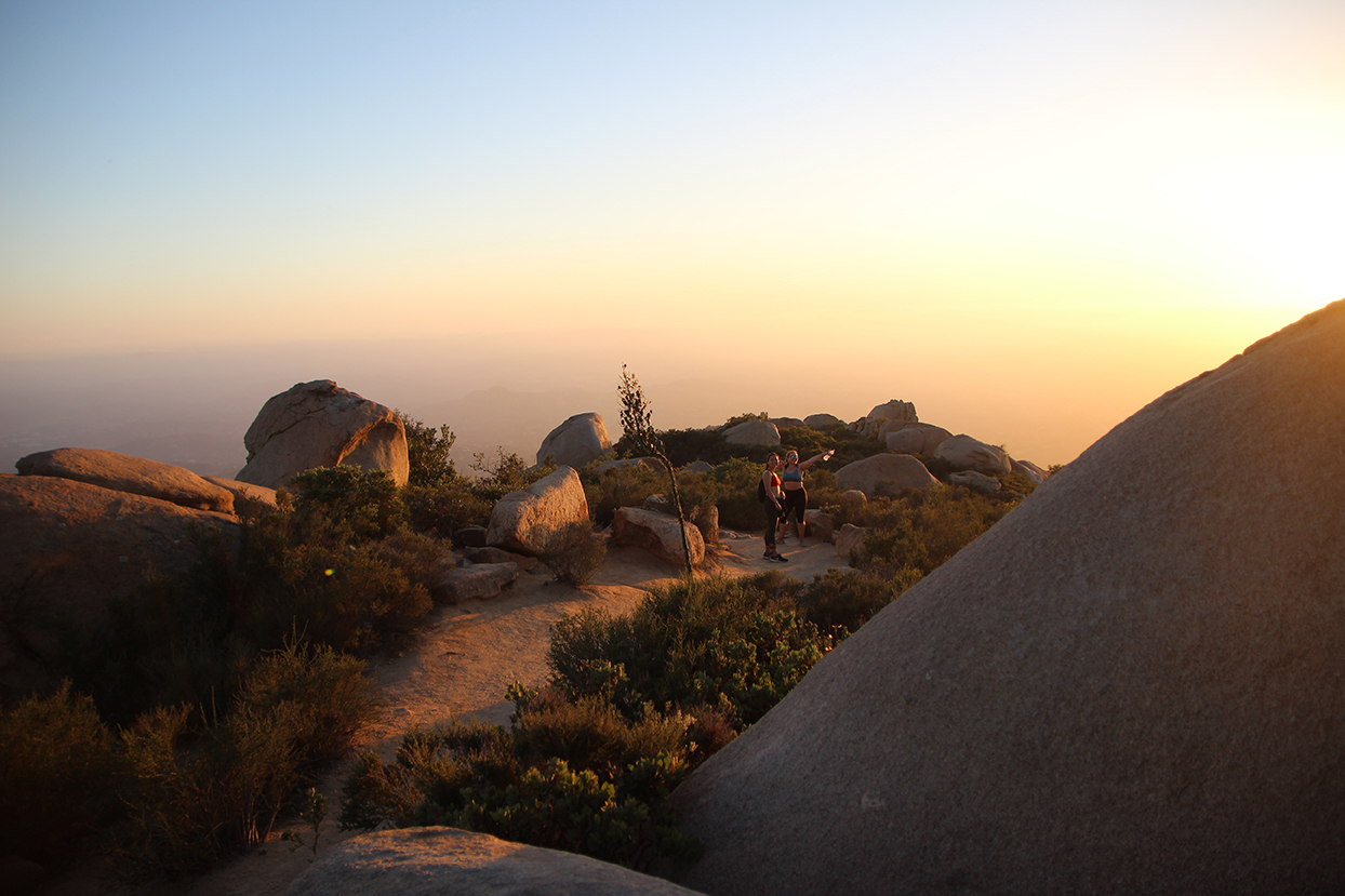
Need a hike that delivers a sense of accomplishment? Try the steep climb to the 6,512-foot summit of Cuyamaca Peak. The Cuyamaca Peak via Azalea Glen Loop offers plenty of challenge and beauty in its 7.7 miles. The terrain is rugged, varying from rocky switchbacks to smooth singletrack, and features both dense pine forests and exposed rock scrambles. Expect to see deer, wild turkeys, and the occasional runner or hiker.


Cuyamaca Peak via Azalea Glen Loop
DEEP & WILD
Like many well-trafficked trails in the West, the Mount Woodson Trail doesn’t disappoint. This challenging 7.5-mile out-and-back route takes hikers to the top of Mount Woodson, offering stunning views of the surrounding mountains, Lake Poway, and the Pacific. Bring water: along with the steep inclines and rocky terrain, you’ll find little to no shade for much of the trail. Don’t miss Potato Chip Rock, a unique formation that juts out from the mountain. Pack a snack, too, in case the landmark makes you hungry.

Mount Woodson Trail
LIGHT & FAST

A more rugged and challenging trail in the Superstition Mountains, the Peralta Canyon Trail covers 6.2 miles while gaining 1,800 feet. You’ll pass by impressive rock formations, including the famous Weaver’s Needle, and you’ll be rewarded with breathtaking views of the desert landscape. Research conditions in advance, and watch for snakes.

Peralta Canyon Trail
Moderate Miles
Got grit? Test it at the Mount Baldy Loop, which covers approximately 16 miles, with a total elevation gain of over 5,500 feet. Start at the Baldy Saddle Trailhead and ascend to the summit of Mount Baldy before descending via the East Baldy Trail. You’ll encounter steep and technical terrain, including rocky ridgelines and switchbacks. Even at max effort, you’ll appreciate views of the surrounding mountains and valleys that are well worth the drive. Bring water, and research conditions beforehand.

Mount Baldy Loop
STEEP & SPICY
Don't have the time to venture outside of town? The Papago Park Double Butte Loop Trail offers a quick hit of nature if you and your legs need it. The mixed dirt-and-paved trail covers approximately three miles, with an elevation gain of around 200 feet. You’ll take in scenic views of the city skyline, unique rock formations, and desert flora and fauna. Too easy? Combine the Butte Loop and other trails within the park for a longer challenge.

Papago Park Double Butte Loop Trail
QUICK & CLOSE
If you haven’t done the Griffith Observatory Trail, it’s time to check it off your list. The trail covers just over 2.5 miles, with a total elevation gain of approximately 500 feet, offering timeless L.A. views of the iconic Griffith Observatory, the city, and the surrounding hills. Without leaving town, you’ll sweat while seeing some beautiful natural scenery—something you can’t do inside a hotel gym. Take the DASH Observatory/Los Feliz route to get there by bus.

Griffith Observatory Trail
QUICK & CLOSE
Ready to get extreme? A hike to the top of Mount Baldy via the Devil’s Backbone Trail will provide. The challenging trail covers 14 miles out and back, while gaining over 4,000 feet. On this bucket-list route, you’ll encounter steep inclines, rocky terrain, and narrow paths toward the summit of Baldy, the highest peak in the San Gabriel Mountains. For your efforts, you’ll be gifted breathtaking views of the surrounding peaks and the Los Angeles basin below.

Devil’s Backbone Trail
STEEP & SPICY
If you enjoy hikes with an embarrassment of sweepingly beautiful views, Solstice Canyon near Malibu is the call to answer. The trail covers a distance of 6.5 miles and features a mix of jaw-dropping coastal and mountain panoramas. While you take in the sights, your feet will power you to a manageable elevation gain of over 1,600 feet. Keep your eyes peeled for the ruins of several mansions.

Solstice Canyon
LIGHT & FAST
In a COVID-era experiment that thankfully continues, a 3.8-mile stretch of road in Ocean Beach called The Great Highway is closed to cars from Friday at noon to Monday at 6 a.m., becoming a welcome promenade. If you’re nearby on a weekend, make use of it for a breezy beachside stroll—minus the sand in your shoes. If you’re without a car, take a bus: MUNI route 7 will get you there.

The Great Highway
QUICK & CLOSE
A truly epic route worthy of any hiker’s bucket list, the Dipsea Trail is a challenging 9.7-mile out-and-back route that’s home to the oldest trail race in the United States. The trail features a mix of steep hills, stairs, and scenic views of the Pacific Ocean and Marin County as it wends its way from Mill Valley to Stinson Beach. After passing through redwood forests and open meadows and crossing over creeks, you’ll arrive at the famed Dipsea Steps, a series of more than 600 steps leading down to Stinson’s white sand.

Dipsea Trail
DEEP & WILD
The killer coastal views and diverse landscape of the 3.4-mile Land’s End Trail make it one of the Bay Area's most-loved loops. Beginning at the Land’s End Lookout, you’ll navigate through cypress and eucalyptus groves, passing by the historic Sutro Baths ruins. Even if you're gassed, stunning views of the Golden Gate Bridge and Pacific Ocean make the wind feel like it's at your back—even when it isn't.

Land’s End Trail
LIGHT & FAST

The Discovery Park Loop checks off a bunch of boxes. For those without the luxury of time, this 2.8-miler provides “just the hits,” from cool tree tunnels to truly stunning views of the Olympic Mountains and Puget Sound. The terrain is mostly flat, with some small hills, so your eyes might get a more challenging workout than your legs. But the trail’s easy access from downtown Seattle makes it a must-do if you’re looking for a quick, scenic hike.

Discovery Park Loop
NO TIME
If you’re feeling your oats, head for the Mailbox Peak Trail, which gains more than 4,000 feet over its 5.2-mile one-way stretch. You’ll curse the steep inclines and rugged terrain but love the eye candy of the surrounding mountains and forests, including the iconic mailbox at the summit. Yes, it’s a real mailbox—not a rock shaped like one. This isn’t an easy go: bring water, check the weather, and research recent conditions.

Mailbox Peak Trail
DEEP & WILD
The Rattlesnake Ledge Trail provides a perfect option for trying to thread the “challenging yet accessible” needle. This four-mile round-trip trail with 1,160 feet of elevation gain is centered around an epic view of Rattlesnake Lake. Expect rocky outcroppings, switchbacks, and plenty of local wildlife—including other hikers. This trail is popular for a reason.

Rattlesnake Ledge Trail
LIGHT & FAST
A convenient option for mellow mountain movers who want to escape the city without straying too far, the Cherry Creek Trail offers a plethora of distance options. Starting at Confluence Park, on the Platte River Trail, this path slices through the heart of Denver and rambles all the way to Cherry Creek Reservoir. Don’t have time for the full 40 miles? Connect Confluence Park to Sunken Gardens Park for a manageable four-mile route. Elevation changes are minimal and the path is paved, so while not the “wildest” trail on the list, the Cherry Creek Trail provides an ideal urban workout getaway.

Cherry Creek Trail
QUICK & CLOSE
While the Colorado Front Range is studded with world-class hikes, a challenge as unique as the Incline in Manitou Springs tops many lung-busting lists. Though the trail covers just under one mile, it gains over 2,000 feet of elevation via a staircase with more than 2,700 steps. You will feel torched as you near the top, but then you’ll find a hiker’s high aided by stunning views of the surrounding Pike National Forest. For a little variety, descend via the switchback-laden Barr Trail.

Incline in Manitou Springs
STEEP & SPICY
With soul-buoying views of surrounding sandstone formations, including the iconic outcrops of the nearby Red Rocks Amphitheater, the South Valley Park Trail in Littleton offers plenty of payoff if you put in the effort. The trail covers just over three miles, with a mix of packed dirt and gravel terrain, rolling hills, and flat stretches for an ideal moderate workout. Don’t miss it.

South Valley Park Trail
MILD MILEs
The 7.2-mile Northern River, Trout Brook, and Prairie Loop at Afton State Park offers plenty for hikers looking to push their limits. You’ll find steep inclines (relatively speaking) with rocky terrain and scenic views of the St. Croix River Valley. While your legs feel the climb, you’ll likely be distracted by the area’s beauty: the trail progresses from dense forest to open prairies to riverbank vistas and back.
Northern River, Trout Brook, and Prairie Loop at Afton State Park
STEEP & SCENIC
Located in Bloomington, a quick drive from Minneapolis proper, the Hyland Lake Park Reserve offers a proper opportunity for trail explorers to pick a route just wild enough for their fitness levels. The 18 miles of trail feature a mix of rolling hills, gradual inclines, and lakeside views. Want to level up? Ascend toward the Hyland Hills Ski Area, where, as you huff and puff, you can take in views of the Twin Cities skyline.

Hyland Lake Park Reserve
WILDER MILES
With only a few hours or less to spare, Theodore Wirth—the largest of Minneapolis’s parks—features a network of trails that span more than 20 miles in total, providing hikers with a variety of options for different distances, difficulty levels, and time constraints. The terrain is a mix of paved paths and unpaved trails that wind through forests, across open fields, and along the shores of several lakes. No ride? Take Metro Transit bus 7 to get there.

Theodore Wirth
no time
The shady, forested Green Ridge Trail at Memorial Park is a favorite destination for Houston mountain bikers, but hikers and trail runners will find a lot to love, too. The popular 2.9-mile loop provides modest elevation change—hey, at least it’s something—along with beautiful views of Buffalo Bayou. You’ll feel far removed from the big city, even though you’re still in it. No car? No problem. Bus route 85 Antoine/Washington runs near the eastern edge of the park.

Green Ridge Trail at Memorial Park
QUICK & CLOSE
Is everything bigger in Texas? Not quite. Yet the Lone Star Hiking Trail, located in the Sam Houston National Forest near Houston, sure impresses. The wildly varied, scenic 96-mile point-to-point provides hikers with a true backcountry trail highlighted by flat sections, steep hills, and rocky terrain. Several campsites are available for overnight stays, or you can attack the trail in sections.

Lone Star Hiking Trail
DEEP & WILD
Shady trails can be hard to come by in Houston, but the Peach Creek Trail delivers with a 4.2-mile loop that’s mostly shaded by canopy. The trail features a mix of flats and steep hills, rocky terrain, and several creek crossings, along with a few sandy sections. Keep your eyes peeled for roots, and consider bug spray if you’re out in mosquito season.

Peach Creek Trail
LIGHT & FAST
It’s not a well-kept secret, for sure, but you can’t go wrong with the Lakefront Trail, truly one of the planet’s great trails. This iconic 18-mile route features a constant source of wonder and motivation: a panoramic view of Lake Michigan and the city skyline. The flat, accessible route passes landmarks like Navy Pier and the Chicago Museum Campus. Plenty of water and rest-stop opportunities exist, making this trail a true choose-your-own-adventure treat.

Lakefront Trail
QUICK & CLOSE
Looking to feel the burn? The Swallow Cliff North Stairs Trail, located near Palos Park, might just have what you need. Though it’s just 2.5 miles, Swallow Cliff offers a demanding workout for trail runners and hikers of all experience levels, thanks to its 293 limestone steps, many put in place by the Civilian Conservation Corps in the 1930s, ascending to a now-closed toboggan run. These days, the stairs provide a rough, rewarding workout among the surrounding forest and its unique rock formations.

Swallow Cliff North Stairs Trail
STEEP & SPICY
Long, leisurely loop trails are hard to come by in this part of the world, but Darien’s Waterfall Glen Forest Preserve offers just that with its scenic 9.5 miles. The mixed gravel trail winds through wooded areas, prairies, and wetlands and features minimal elevation change. Local eye candy includes waterfalls, streams, and lakes, along with deer, foxes, and birds—plus a handy Porta-Potty halfway through the route.

Waterfall Glen Forest Preserve
LIGHT & FAST
A Big D classic, the White Rock Lake Trail offers a 9.3-mile loop around White Rock Lake, a circa-1900 reservoir. With extremely gentle grading, it’s a great cruise for all fitness levels (until temperatures start peaking in summer, of course). The trail offers killer views of the water, the Dallas skyline, and restored meadows. It’s a popular spot that tends to be busy on weekends, but you’ll enjoy the camaraderie and a vibe that’s far removed from the city.

White Rock Lake Trail
QUICK & CLOSE
If you need a big break from the city, the DORBA Trail at Cedar Hill State Park delivers. This challenging trail system can be adapted from a 4.8-mile loop to much longer options and features steep hills, technical sections, and rocky terrain—along with epic views of the 791-acre Joe Pool Lake. Be on alert for mud after rainy stretches, and keep your eyes peeled for snakes.


DORBA Trail at Cedar Hill State Park
DEEP & WILD
The Greenbelt Corridor Trail at the Isle du Bois Unit of Ray Roberts Lake State Park satisfies both the mind and body with up to 20 miles of just-rugged-enough trails studded with scenes to entertain the eye. The trails wind through dense forests, open fields, and along the banks of Lake Ray Roberts, providing hikers and runners with cool viewpoints of the water and the surrounding natural beauty. You’ll pass over historic bridges, see a bottomland hardwood forest, and, in spring, bear witness to some sweet wildflower fields.

Greenbelt Corridor Trail
LIGHT & FAST


Nichole Iby

Take it From a Goat
Nichole Iby

Nichole Iby
"As I was hiking up a steep rock scramble in the White Mountains, I realized how solid my grip felt in the Facet Mid trail shoes. New Hampshire is known for having some of the toughest hiking terrain in the Northeast, but these shoes have the support and goat-like traction I need to feel confident taking on any trail!"
-Nichole Iby


Himalayan Tahr:
Alpine Ibex:
LaMancha Goat:
Miniature Silky Fainting Goat:
Angora Goat:
Texas Wooden Leg:
Toggenburger:
Golden Guernsey:
Capricorn:


Embrace your inner mountain goat and learn to tackle challenging terrain and thrive in wild landscapes
Highline Trail—Glacier National Park, Montana
Mountain goats often hang out right at the Logan Pass parking lot, where this classic trail begins, but don’t stop there. This mostly flat trail hugs a vertiginous slope above a lush valley and traces the flower-filled Garden Wall.
Wonderland Trail—Mount Rainier National Park, Washington
This epic loop trail circles Mount Rainier over 93 miles, rolling up and down lots of goat-friendly terrain. Try the trip to Summerland and Panhandle Gap for a day-hike-size chunk with gorgeous views.

Mount Evans Summit—Mount Evans Wilderness, Colorado
You can drive almost to the top of this 14,268-foot peak, or you can hike its west ridge for a much more challenging hike. Either way, you’ll probably see the fourteener’s resident mountain goats when you’re up there.

Goat Code:
Enjoy watching mountain goats from a distance (like any wildlife). These big, horned creatures can be aggressive—they’ve charged and seriously injured hikers. It’s also good form to pee where mountain goats can’t get to it: in an outhouse, where available, or in between larger rocks if possible. Goats are attracted to the salt in human urine. When lots of people pee on the same areas near trails, goats tend to congregate, posing a safety risk.
Amanda Bittner

"The hike up to the old gold mine was pretty rocky and steep and the goats were right at home on the climb up. Facet Mids definitely helped me channel my inner goat and keep pace!"
amanda bittner

Take it From a Goat
Wilderness Goat Packers
Researcher and naturalist John Mionczynski earned the nickname “the father of goatpacking” back in the 1980s in Wyoming when he fine-tuned a system for turning goats into backcountry pack animals (and perfected his backcountry goat’s-milk yogurt recipe). With his outfitting company, Wind River Pack Goats, he hauled both his own wildlife research tools and backcountry gear for expeditions into the Wyoming wilderness. Mionczynski wrote the book on goatpacking; today, outfitters across the West offer their own guided trips.
The First Goat Yoginis
These days, you can find goat yoga classes on farms across the country, where practitioners happily let baby goats balance on their backs during child’s pose and cobra. It all started in 2016, when farmer Lainey Morse realized that visitors interacting with goats on her farm was a form of animal therapy. A local yoga instructor asked to hold a class among the goats, and voilà!—goat yoga was born. (Morse believes this class was the world’s first goat yoga session.)
The Surfing Goats of Pismo Beach
California surfer Dana McGregor taught his pet goat to surf—yes, really. Now, he leads surfing clinics for humans and pets (choose to learn with or without a four-legged companion) and leads goat hikes (fresh goat milk included). He also runs a surf camp for special-needs kids.
Adventures with Goats
Everybody likes goats. But some people absolutely love them. Meet five crews of adventurous ungulates—and their humans—pushing the boundaries of where goats can go.
Goats of the Future
Willie Morris believes goats can help people “reimagine their relationship with food without being preachy about climate change.” The tech entrepreneur and rock climber co-founded The Happy Goat, a nonprofit regenerative farm in the Sierra foothills outside Yosemite National Park, to prove it. There, more than 200 goats graze on grasses and munch on poison oak, helping clear land for fire mitigation while producing humane, no-kill, organic wool and fertilizing food supplied to restaurants in nearby Mariposa, California. The budding “carbon farm,” camp, and creative retreat also leverages sales of goat NFTs to support the mission of a future based in healthy soil.
Landscape-Restoring Goats
Why rely on poisonous herbicides and expensive firefighting techniques when you have goats? Lani Malmberg grazes her herd of 1,500 goats on landscapes across the West to provide natural weed control, wildfire mitigation, and soil replenishment. Working everywhere from the frozen plains to the mountaintops, these goats leave every site better than they found it.
Goats Don’t Need Trekking Poles—But You Do
Mountain goats can handle slopes without any extra hardware, but human hikers would do well to add some extra points of contact when the going gets steep. Here’s how best to choose and use trekking-pole appendages:
How to Climb Like a Goat
Why Goats Like Steep Terrain
What Goat Are You?
Find your new favorite goat that best defines your style of outdoor adventure. Click through the gallery at left to find your match.
• Don’t get “cliffed out.” This happens when you downclimb onto a ledge that you can’t easily get off of. Avoid this by carefully scouting your route up and down the summit.
• Pack the right gear. You’ll want a map and compass, plus your preferred navigation technology (GPS or app), as trails tend to fade away in scrambling territory. Hiking shoes with great traction and support are a must.
• Face into steep slopes for the most secure position, including when you’re descending.
• Avoid traveling directly above or below others, as someone could dislodge a rock that could seriously injure or kill a climber below.
• Test handholds and rocks underfoot before you put your full weight on them. Make sure a boulder you step on won’t move.
• Maximize your surface area by keeping as much of your boot's sole as possible in contact with the rock, rather than trying to climb with just your toes. The more surface area touching the slope, the more friction you'll create, which will help prevent slipping.
• Know the ratings.
Mountaineers rate routes on a scale from Class 1 to Class 5, with Class 1 being a straightforward hike and Class 5 being a technical rock climb. Class 3 is perfect scrambling territory: expect to use your hands to ascend, but a fatal fall is highly unlikely. Class 4 terrain can also be good for scrambling, but it’s much more exposed, and gearing up with a helmet, rope, and harness is advisable.
• Choose your route slowly and carefully.
Always maintain at least three points of contact with the slope, whether that's two hands and one foot or two feet and a hand.

Scrambling 101
Keen to explore the airy terrain where mountain goats frolic? Make sure to master these key scrambling skills first. Scrambling refers to a middle ground between hiking and mountaineering—you’re usually not roped up, but you’ll need your hands for balance. Typically, scrambling happens on low-angle rock, talus, or scree as you’re approaching a summit.


More baby bighorns
BAH!
Mountain goat kid
German white goat kids
Baby golden Guernsey
Springing forward to new terrain
Columbia has been creating innovative apparel, footwear, accessories and equipment for outdoor enthusiasts since 1938. Columbia has become a leading global brand by channeling the company’s passion for the outdoors and innovative spirit into technologies and performance products. To learn more, please visit www.columbia.com.
presented by


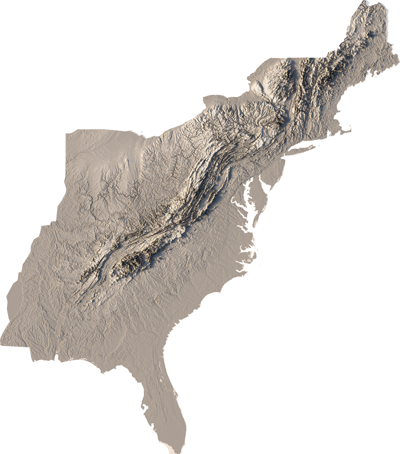
EAST
CENTRAL
west

EAST
CENTRAL
west
STEPHEN MARTIN

"On a Colorado off-trail scramble chasing my two canine mountain goats-in-training, the Facet Mids provided the perfect cross-section between comfort, style, and most importantly performance, with hyper-grippy soles that tackled the toughest terrain."
STEPHEN MARTIN

Take it From a Goat