Beginning of dialog window. Escape will cancel and close the window.
End of dialog window.
Video Player is loading.
Loaded: 0%
0:00
Current Time 0:00
/
Duration 0:21
Remaining Time -0:21
1x
Chapters
descriptions off, selected
default, selected
This is a modal window.
Beginning of dialog window. Escape will cancel and close the window.
End of dialog window.
Video Player is loading.
Loaded: 0%
0:00
Current Time 0:00
/
Duration 0:20
Remaining Time -0:20
1x
Chapters
descriptions off, selected
default, selected
This is a modal window.
Beginning of dialog window. Escape will cancel and close the window.
End of dialog window.
LEARN MORE
HOME
HURRICANES
FLOODING
FIRES
TORNADOS
SNOW & ICE
HURRICANES
HURRICANES
More Accurate and Timely Forecasting
Our Cross-Track Infrared Sounder (CrIS) measures 3D temperature and moisture profiles from many levels of the atmosphere to support more accurate prediction modeling. CrIS data helps pinpoint hurricane track and intensity, reducing the cone of uncertainty and providing vital time to plan and prepare.
Video Player is loading.
Loaded: 0%
0:00
Current Time 0:00
/
Duration 0:09
Remaining Time -0:09
1x
Chapters
descriptions off, selected
default, selected
This is a modal window.
Beginning of dialog window. Escape will cancel and close the window.
End of dialog window.
+5d
+4d
+3d
+2d
+1d
2010 CONE
2020 CONE
2030 CONE*
*theoretical
Improved numerical weather predictions
Video credit: NOAA
Built to Evolve
With unprecedented speed and accuracy, L3Harris’ Advanced Baseline Imager (ABI) simultaneously scans the entire western hemisphere every 10 minutes, the continental United States every five minutes and areas of rapidly developing storms every 30 seconds. Its flexibility enables us to develop even more powerful imaging technology to meet future demands.
Video Player is loading.
Loaded: 0%
0:00
Current Time 0:00
/
Duration 0:12
Remaining Time -0:12
1x
Chapters
descriptions off, selected
default, selected
This is a modal window.
Beginning of dialog window. Escape will cancel and close the window.
End of dialog window.
HIGH RISK IN 6 HOURS
Flexible Rapid Scanning
Video Player is loading.
Loaded: 0%
0:00
Current Time 0:00
/
Duration 2:03
Remaining Time -2:03
1x
Chapters
descriptions off, selected
default, selected
This is a modal window.
Beginning of dialog window. Escape will cancel and close the window.
End of dialog window.
Video Player is loading.
Loaded: 0%
0:00
Current Time 0:00
/
Duration 0:21
Remaining Time -0:21
1x
Chapters
descriptions off, selected
default, selected
This is a modal window.
Beginning of dialog window. Escape will cancel and close the window.
End of dialog window.
Video Player is loading.
Loaded: 0%
0:00
Current Time 0:00
/
Duration 0:24
Remaining Time -0:24
1x
Chapters
descriptions off, selected
default, selected
This is a modal window.
Beginning of dialog window. Escape will cancel and close the window.
End of dialog window.
LEARN MORE
HOME
HURRICANES
FLOODING
FIRES
TORNADOS
SNOW & ICE
WEATHER MISSION SOLUTIONS
Managing a growing constellation of satellites and sensors, rapidly processing even larger volumes of data and quickly delivering information and products to users worldwide requires a pivot to cloud-native technologies. L3Harris is investing in high-performance computing, machine learning and artificial intelligence technologies to architect a scalable ground system of the future – empowering customers to focus on future missions rather than hardware and facilities.
DOWNLOAD
PDF
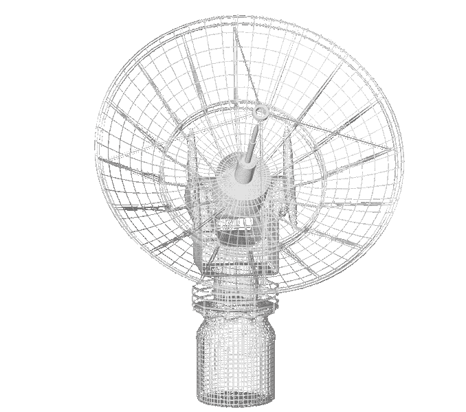
Cross-track Infrared Sounder (CrIS)
Built by L3Harris, NOAA's CrIS is the most advanced smallsat compatible sounding instrument in LEO and one of the top contributors to forecast accuracy.
L3Harris is evolving CrIs's proven, on orbit accuracy with solutions that are smaller and more affordable without sacrificing performance.
FUTURE
CURRENT
CURRENT
Video Player is loading.
Loaded: 0%
0:00
Current Time 0:00
/
Duration 2:03
Remaining Time -2:03
1x
Chapters
descriptions off, selected
default, selected
This is a modal window.
Beginning of dialog window. Escape will cancel and close the window.
End of dialog window.
Video Player is loading.
Loaded: 0%
0:00
Current Time 0:00
/
Duration 0:21
Remaining Time -0:21
1x
Chapters
descriptions off, selected
default, selected
This is a modal window.
Beginning of dialog window. Escape will cancel and close the window.
End of dialog window.
Video Player is loading.
Loaded: 0%
0:00
Current Time 0:00
/
Duration 0:25
Remaining Time -0:25
1x
Chapters
descriptions off, selected
default, selected
This is a modal window.
Beginning of dialog window. Escape will cancel and close the window.
End of dialog window.
LEARN MORE
HOME
HURRICANES
FLOODING
FIRES
TORNADOS
SNOW & ICE
HOME
PREDICTING ENVIRONMENTAL DISASTERS BEGINS IN SPACE
When it comes to environmental disasters like forest fires, flash floods, hurricanes, tornadoes and blizzards, seconds can be the difference between life and death. Our innovative weather satellite solutions increase warning times, enhance long range predictions and enable better estimates of storm intensity – to create a safer, more weather-ready nation.